Ever realize there are numbers on the turnstiles?!!
Turnstile at Columbus Circle Station
Ever realize there are numbers on the turnstiles?!!

Turnstile at Columbus Circle Station
For the longest time, subway stations were represented by a singular symbol "M" on most map apps. I just realized recently that since iOS 9, apple map has been showing the footprints of the stations in faint pink, and individual exits in little orange dots, like in this screen shot:

Even though these are 2-D, this additional layer of information is in line with the goal of Project Subway NYC, which is to understand the subway stations not as a single point in space, but as part of a network that branches to various destinations in the city. So now if you have an iphone, you don't have to rely on MTA's neighborhood maps alone. Pretty neat, pretty neat!
New York City is a beautiful and exciting city, especially when you have time and it’s nice outside, it’s delightful just to walk around and look around. But then there are also bad days, when you are in a hurry and it’s cold and rainy… on those days, if you had to take the subway, you would either want to be underground for as long as you can, or to have the most efficient way around the station, right?
There are signages in the subway stations, but they don’t give you an overall picture of what the stations look like. In light of that, I have taken the initiative to illustrate some of the more complex stations, as well as the landmarks and popular destination points around them. Let’s look at the 59th Street Columbus Circle station:
59th Street Columbus Circle Station layout map
Disclaimer: Drawing is not to scale and only shows the approximate and relative location of things
The 1 train runs on the upper level, along the diagonal Broadway, and the A / C and B / D trains run on the lower level, straight along 8th Ave / Central Park West. On both levels, the east tracks go uptown and the west tracks go downtown.
Read more at http://www.turn-style.com/
To transfer between uptown and downtown trains, the shortest path is the walkway between the tracks on the lower level. I marked it with a red dotted line in the graphic. It has a wavy guardrail and it looks like this:
So this is the first of a series of blog posts I plan to do for the five stations I have picked. More to come!
I am an architect, so I am no stranger to surveying spaces from scratch. Still, it would be great to have something to base my drawings off of. To begin my quest, I went into the stations to look for the maps that tell you where the exits are. They look like this:
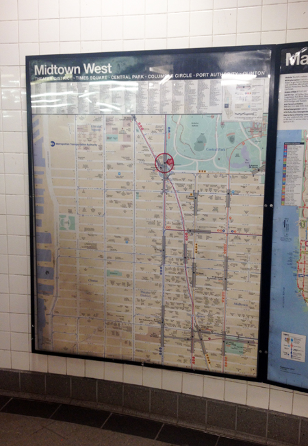

And so I thought alright, I’ll just have to go to each station to take a picture of the map. And then I thought, is there a chance these maps are online? So I went home and did a quick search and bam! Here they are:

Find all neighborhood maps like this one at http://web.mta.info/maps/neighborhood_maps.htm
They are called “neighborhood maps” under “maps” in mta.info.
They are neither editable nor printable, but a quick print-screen will do. With them, I am ready to go out and take some actions!