#JustKeepSketching


WORK IN PROGRESS
I am trying to do something but it's not really going the way I want it to. So I just mindlessly Photoshop some textures, add some filters and shadows, and layer things on top of each other... this is a random moment that I quite like:

4"x6" postcards
Launching postcards of the X-ray series at the end of the year... test batch is looking good!
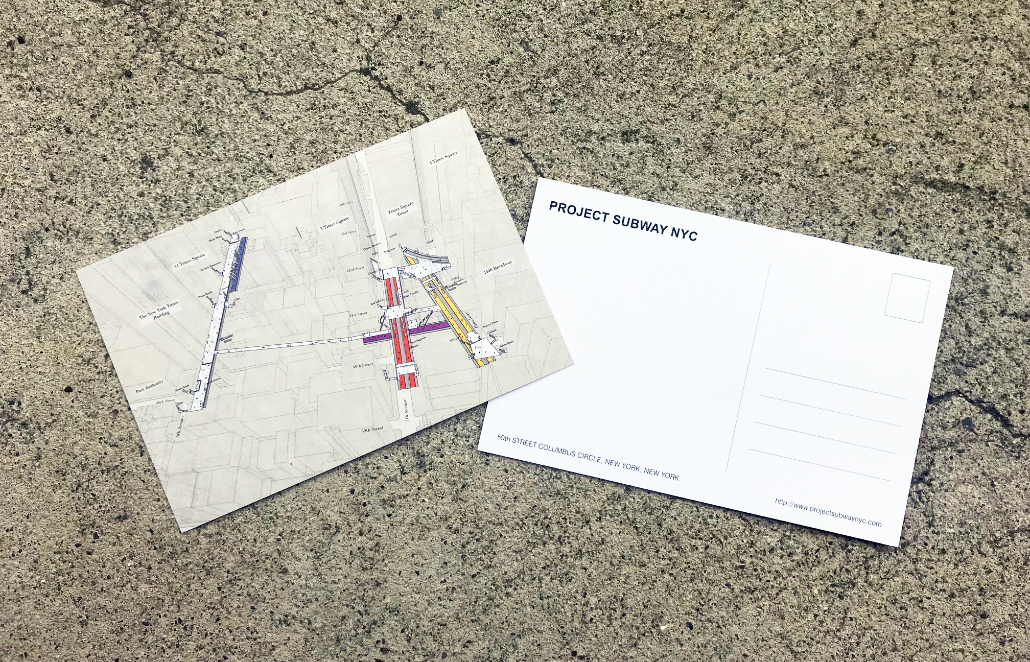
times square postcard - front and back
IT'S HERE: THE ATLANTIC AVENUE - BARCLAYS CENTER PRINT!
By popular demand, the Atlantic Avenue - Barclays Center print is finally ready! After four visits and God knows how many sketches. Check it out in our gallery and shop!
This is Project Subway NYC's second attempt to look into stations in Brooklyn, hope to do more soon. Let me know in the comment which stations you want to see, and don't forget to follow us on facebook and instagram (@projectsubwaynyc) for updates!
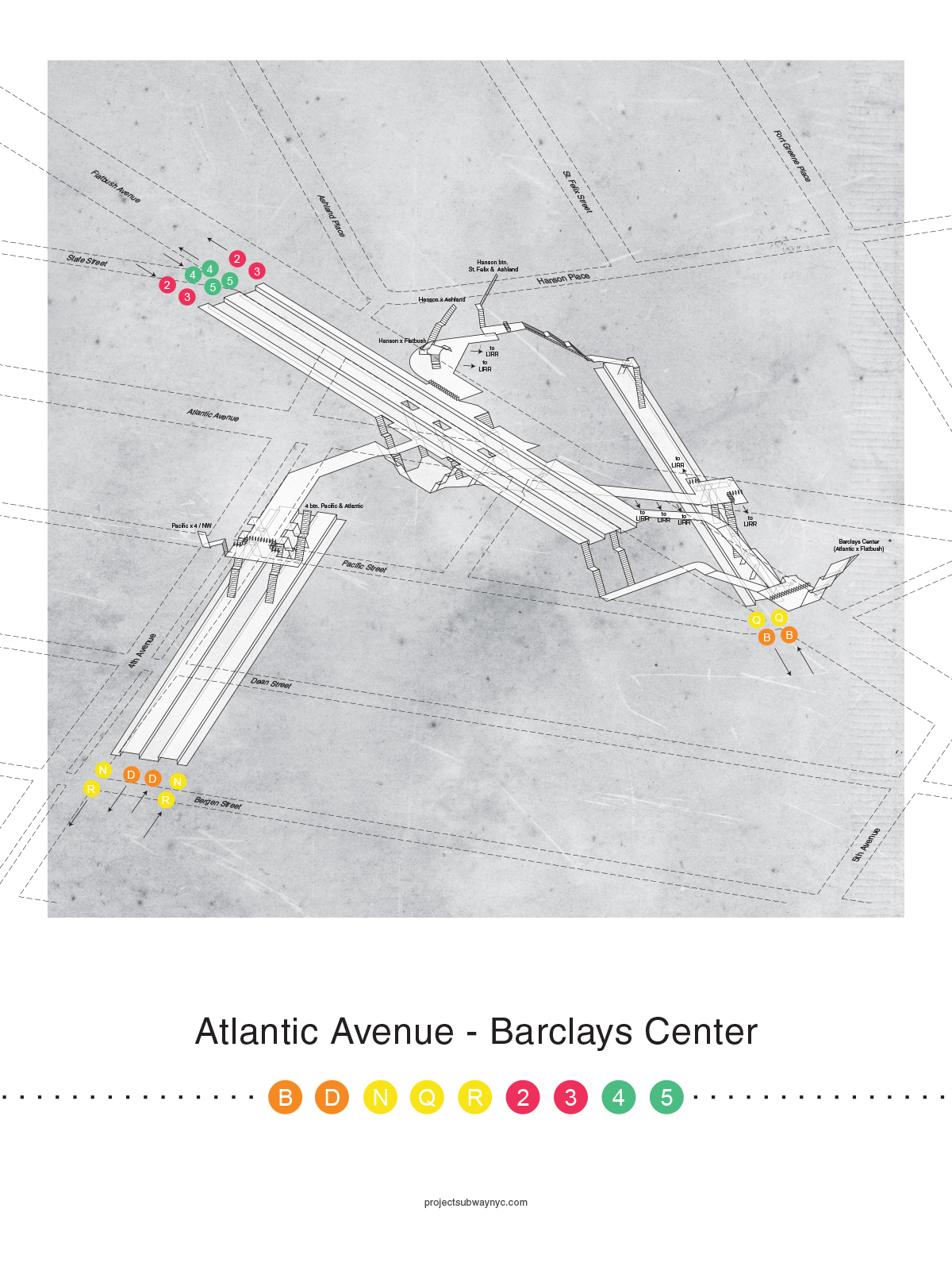
Atlantic Avenue - Barclays Center Poster

sketch - cad - print - sketch again
3D TRACK MAP TRAIL #2
Work in Progress -
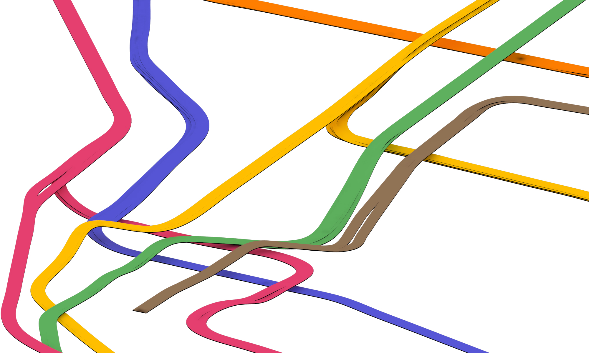
NYC Subway 3D Track Map - Downtown

NYC Subway 3D Track Map - Midtown and Midtown West
I tried to model the entire area of Manhattan below Central Park in 3D but turns out the lines are too thin and the changes in elevations look to subtle when you zoom out in a bird's-eye view. So I had to exaggerate the width of the tracks. But after rebuilding the 2D lines in Rhino the lines look so wiggly, so it looks a little weird now. I will try to make a cleaner and neater version!
3D TRACK MAP SKETCH
This is my first attempt

3D Track Map Sketch of the lower half of Manhattan
PUTTING IT TOGEHTER
So far I have been trying to study NYC's subway system one station at a time. Now that I have collected some twenty plus stations, I figure it's time I zoom out and look at how the stations relate to one another. When I put all the individual stations where they belong on the map, it looks like this:

Lower Half of Manhattan in Aerial View
It gets tricky when I try to connect the dots - the tracks are really a vast network that gets interwoven together with a lot of ups and downs. Tracks that are parallel in one station sometimes get stacked on top of each other in another. They also split and merge, from local to express, and from inner to outer tracks. Here is my first attempt at figuring out the Columbus Circle area:

First Attempt at Sketching Tracks between Stations
Luckily nycsubway.org has a wealth of information to help me out. It has track maps that show which track is above which, like this:

Source: http://www.nycsubway.org/perl/caption.pl?/img/trackmap/detail-cityhall.png
NEW PRINTS ARE HERE!!
I am excited and proud to share that the new batch of four prints are finally here! This batch includes four stations from downtown: Delancey Street - Essex Street (F / M / J / Z), Chambers Street - Park Place - World Trade Center (A / C / E / 2 / 3), Chambers Street - Brooklyn Bridge - City Hall (J / Z / 4 / 5 / 6), and Bleecker Street - Broadway - Lafayette Street (B / D / F / M / 6). I have to say, once the stations are not on numbered streets and avenues, I found it way harder to wrap my head around things - but I did it!
Check them out in our gallery and shop page! Apply promo code DOWNTOWN to get 10% off all orders.

Delancey - Essex

Brooklyn Bridge - City Hall
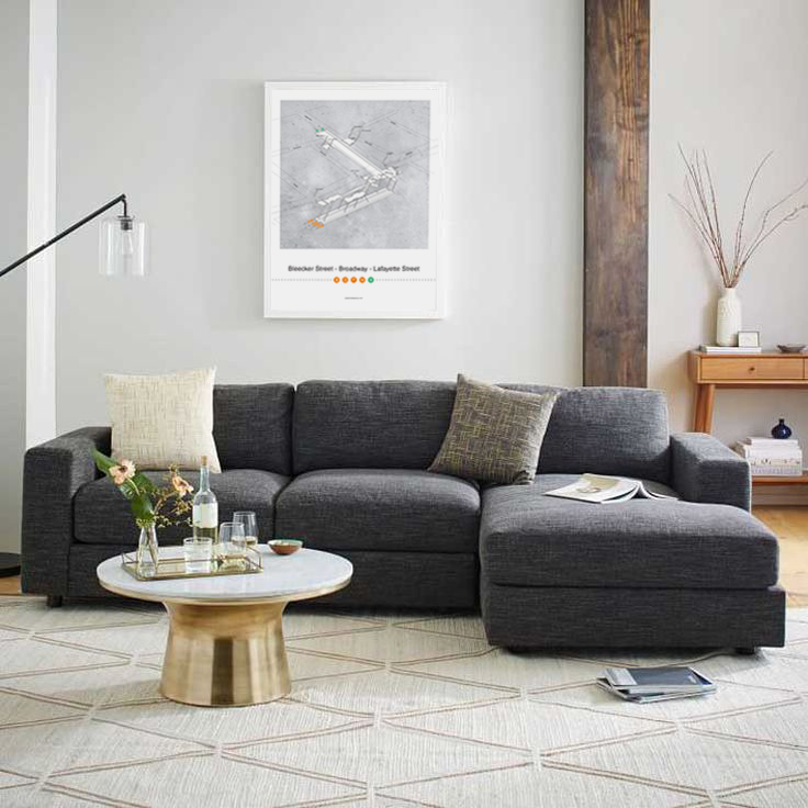
Broadway - Lafayette

World Trade Ceter
CHAMBERS ST / PARK PLACE / WORLD TRADE CENTER - CONT'D
This is the 4th visit already, I have a feeling I will never get this station right..

CHAMBERS ST / PARK PLACE / WORLD TRADE CENTER
This is basically three stations in one, and it's really really loooooong..

Stations, Escalators, and High Fives
Like other stations on 53rd street, the 53rd Street - Lexington Avenue station is a really deep one. Look at the sketch and the numbers I wrote down, there are 5+ sections of stairs of 15 steps each that lead you to the E/M tracks - that's more than 3 stories in one run of escalator (and that only brings you to the mezzanine! You'll have to go up one more to reach ground).
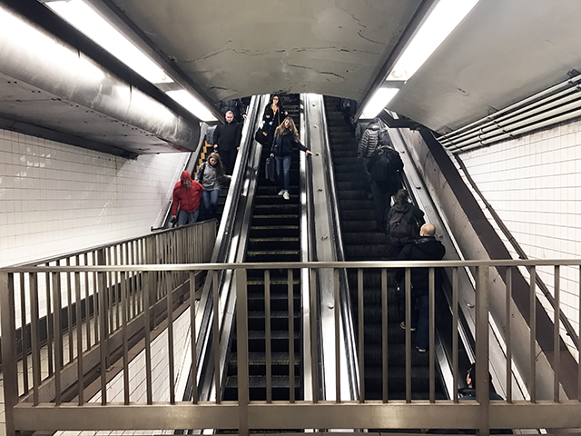
Giant Escalator in 53rd Street - Lexington Avenue Station

Sketch of Stair and Escalator in 53rd Street - Lexington Avenue Station
And then I suddenly thought to myself, that looks familiar - that's where the "imrpov everywhere" people did the "high five escalator"!
This is another example of how understanding these circulation spaces in the stations can offer so many interesting opportunities.
And when you reach the top of it, there is a really beautiful, yellow mural on a curvy wall:
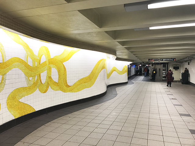
Mural at 53rd Street - Lexington Avenue Station
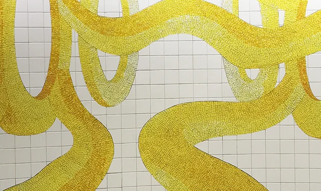
Mural at 53rd Street - Lexington Avenue Station

Sketch of Mezzanine Level at 53rd Street - Lexington Avenue Station
14TH STREET - 6TH AVENUE AND 7TH AVENUE (1/2/3/F/M/L)
This station has sooooo many entrances, 19 to be exact!

14th Street - 6th Ave and 7th Ave Neighborhood Map


( And I just realized there is "FML" in the station name...haha.)
14TH STREET STATION (A / C / E / L) - CONT'D
More Sketches
STATION FOOTPRINTS IN APPLE MAP
For the longest time, subway stations were represented by a singular symbol "M" on most map apps. I just realized recently that since iOS 9, apple map has been showing the footprints of the stations in faint pink, and individual exits in little orange dots, like in this screen shot:

Even though these are 2-D, this additional layer of information is in line with the goal of Project Subway NYC, which is to understand the subway stations not as a single point in space, but as part of a network that branches to various destinations in the city. So now if you have an iphone, you don't have to rely on MTA's neighborhood maps alone. Pretty neat, pretty neat!
I'M BACK AND READY TO ROLL AGAIN
I went back to Hong Kong for Chinese New Year in the beginning of this month, and here is a picture of me standing next to the station map at Tai Wai, where I am from. It was interesting going back to where it all started, and I am even more convinced today that this project is worth pursuing.

Me next to the Tai Wai station map
My break from this project was longer than I thought it would be - but now that I am back in NYC, refreshed and energized, I am ready to start drawing again!
SEASON'S GREETINGS + THE SUBWAY MAP X'MAS TREE
As the holiday season approaches I decided to take a break from drawing (If you haven't voted though, please do so because I will most probably start drawing again in January).
Every year I try to find a creative way to make a Christmas tree, and this year there's no better theme than the subway theme, check it out:
Subway Map Origami Christmas Tree
Subway Map Origami Christmas Tree
If you want to make your own, you can follow these instructions:

Or you can watch this video too:
On behalf of Project Subway NYC, I wish everyone a year of much love, happiness, and not too many train delays. Happy holidays!
UPDATED 7 TRAIN ARROWS IN POSTER #42
Since the 34th Street – Hudson Yards station was opened in September this year, I have updated my Times Square drawing to show 7 train running both ways!

Both arrows pointed to the right in the old version

WORK IN PROGRESS - CANAL STREET
Having picked up some fishballs from the supermarket and sipping bubble tea, I found myself in the Canal Street station.

Canal Street Station Sketch
See this part is so tight they have to put a railing to prevent people from walking straight into the track..
And there is this part of the station I have never been to, with this wall with funny symbols:

34th ST HERALD SQUARE STATION EXPLAINED – HOW TO GET TO KOREAN TOWN
Midtown is one of the busiest areas in Manhattan, especially during rush hours, with all the people, cars, and bicycles going full speed in every direction, it could be annoying and sometimes dangerous to walk around there.
The 34th Street Herald Square station is big – it spans three blocks north-south, from 32nd to 35th street, and it’s at the intersection of 6th Avenue and Broadway. Now if you want to avoid all the hustle and bustle on the streets, getting out of the exit closest to your destination is the key. It will not only make your life easier but also save you some precious time!
I personally go there a lot for Korean food (Seoul Garden is my go-to for get-togethers.. kalbi and tofu soup is the perfect combo!). And so I decided make a diagram to illustrate the most efficient way to get out of it:
How to get to Korean Town in NYC
Disclaimer: Drawing is not to scale and only shows the approximate and relative location of things
WHERE YOU ARE GOING
Korean town (a.k.a. the “Korea Way”) is the block on 32nd street between 5th and Broadway. The closest subway exit is on the NE corner of 32nd and Broadway. To get there, simply follow the red dotted line in the diagram, or follow these instructions:
Korea Way (image source)
IF YOU CAME FROM THE B / D / F / M LINE
1. First, no matter where you are, walk to the far south end of the platform.*
2. Go up the stairs, to the mezzanine. There, you will see a bunch of turnstiles, but do NOT go out of them. Instead, look for the N / Q / R sign and follow it, and go up the stairs:
Follow this red arrow
Go up these stairs
3. Then you will be on the upper mezzanine level. Now go through the turnstiles, and go to the exit on your far left. There is a sign that says “32nd Street and Broadway NE Corner”. That’s your exit!
This is the exit closest to Korean Town!
IF YOU CAME FROM THE N / Q / R LINE
- Go to the far south end of the platform and go up the stairs.*
- Go to step 3 of above.
* If figuring out which way south is isn’t intuitive to you, do this: if you were on an uptown train, walk opposite to the direction the train is going, and vice versa :P
And that's it! Once you find that exit and get out of it, it's all the glorious Korean food waiting for you. Yum!