LEARNING FROM SEOUL

Just came back from Asia! This time I stopped by Seoul - nice city! It was a short trip but I managed to ride their metro a few times and notice some interesting things about the way signage is done.

This sign gives you the distance to the nearest exit in meters:

IMG_7921.JPG

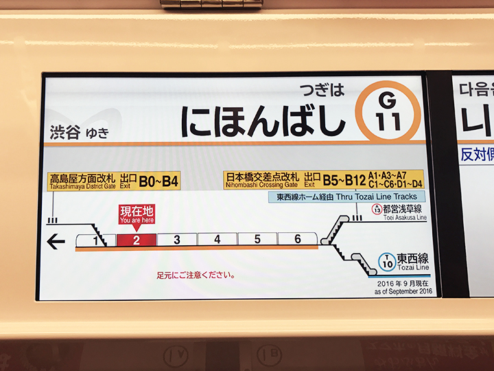
This one gives you the previous station and the next station (as opposed to the terminal station of that line):

IMG_7901.JPG

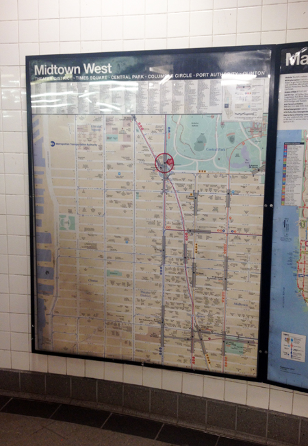
And this one is a 2D map with 3D buildings - a hybrid. I am not sure how I feel about it, but I am intrigued!

IMG_7858.JPG

LEARNING FROM TOKYO

I went travelling in Tokyo back in February, and I was intrigued and inspired to see how graphics and information work in their subway system.

Even though I took on the quest to illustrate NYC's subway stations in 3D drawings, I have come to realize that because of the intricacy and complexity of the stations, a single drawing that shows one entire station often proves hard to understand. Therefore I have been looking for ways to represent the stations and directions in bite-size, easy-to understand information for subway riders.

In Tokyo, each train car has a digital display that shows the number of the car, the train's travel direction, as well as the location of escalators and elevators on the platform. Some of them also show transfer directions. My friend Ana told me that it was invented by a mom who could never get home on time because she was always lost in the stations - I find it very clever and helpful - comprehensive yet easy to understand!

THE PROCESS

When I started this project, I naively thought I could just go walk around in the stations, take some pictures, and sketch the stations out casually like this:

But in reality, it was way harder than I thought. In order to work out where things are relative to each other, I had to developed a process to visualize the stations step by step. First, I document the entrances (from streets to turnstiles) on the neighborhood maps:

Then I make 2D drawings in the computer:

And then I go back and sketch some more, verifying my guesses and adding things I missed:

Then I model it in 3D:

And I render it:

And all of these steps kinda go back and forth and back and forth until I get the overall picture. The final graphic will be a combination of all of these. Almost there!

GETTING STARTED

I am an architect, so I am no stranger to surveying spaces from scratch. Still, it would be great to have something to base my drawings off of. To begin my quest, I went into the stations to look for the maps that tell you where the exits are. They look like this:

And so I thought alright, I’ll just have to go to each station to take a picture of the map. And then I thought, is there a chance these maps are online? So I went home and did a quick search and bam! Here they are:

Find all neighborhood maps like this one at http://web.mta.info/maps/neighborhood_maps.htm

Find all neighborhood maps like this one at http://web.mta.info/maps/neighborhood_maps.htm

They are called “neighborhood maps” under “maps” in mta.info

They are neither editable nor printable, but a quick print-screen will do. With them, I am ready to go out and take some actions!


Pilot

It all started when my old office moved downtown to the financial district. The office is on Broadway, somewhere near the Fulton Street station. The station is HUGE -  there are so many exits that it was very confusing, and it took me and my coworkers forever to figure out how to get to the exit nearest to the office.

I am from Hong Kong, and in Hong Kong’s MTR (subway) stations, there are diagrams like these on the walls:

List of station layouts can be found here: http://www.mtr.com.hk/en/customer/services/system_map.html

List of station layouts can be found here: http://www.mtr.com.hk/en/customer/services/system_map.html

A quick search shows that Japan has similar:

And I thought to myself, why isn’t there any in NYC’s stations? Fulton Street is definitely not the only complex station, and I can't be the only person who wishes there is some form of visualization to help one find his way inside the station.

So I gave myself the challenge to make it happen, and this blog will be a record of this journey.